


 SHARE:
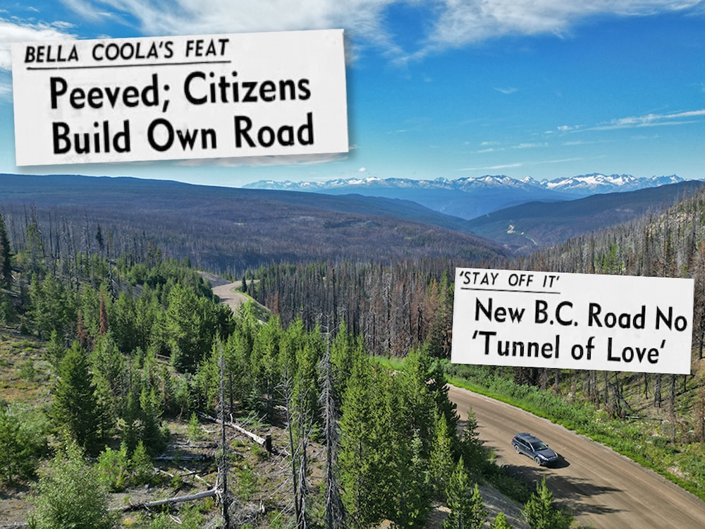
In October 1953, Andy Svisdahl became the first person to travel by road from Bella Coola to Vancouver. He arrived with a warning: Don’t do it.
It had taken the 33-year-old mechanic five days to drive from B.C.’s central coast to the Lower Mainland. His clutch had failed 10 kilometres into the journey and he was towed 65 kilometres up Heckman Pass, along one of the steepest and most scenic roads in Canada.
The route would offer “real tourist attractions when the road is improved,” Svisdahl told the press when he arrived.
“Even though the road angles like a jagged streak of lightning in spots and cars sink in mudholes halfway up to their doors, the residents of Bella Coola are pretty proud of it,” the Vancouver Sun reported on Oct. 17, 1953.
Today, the road out of the Bella Coola Valley is known simply as the Hill.
Locals are still proud of it. And tourists are still wary.
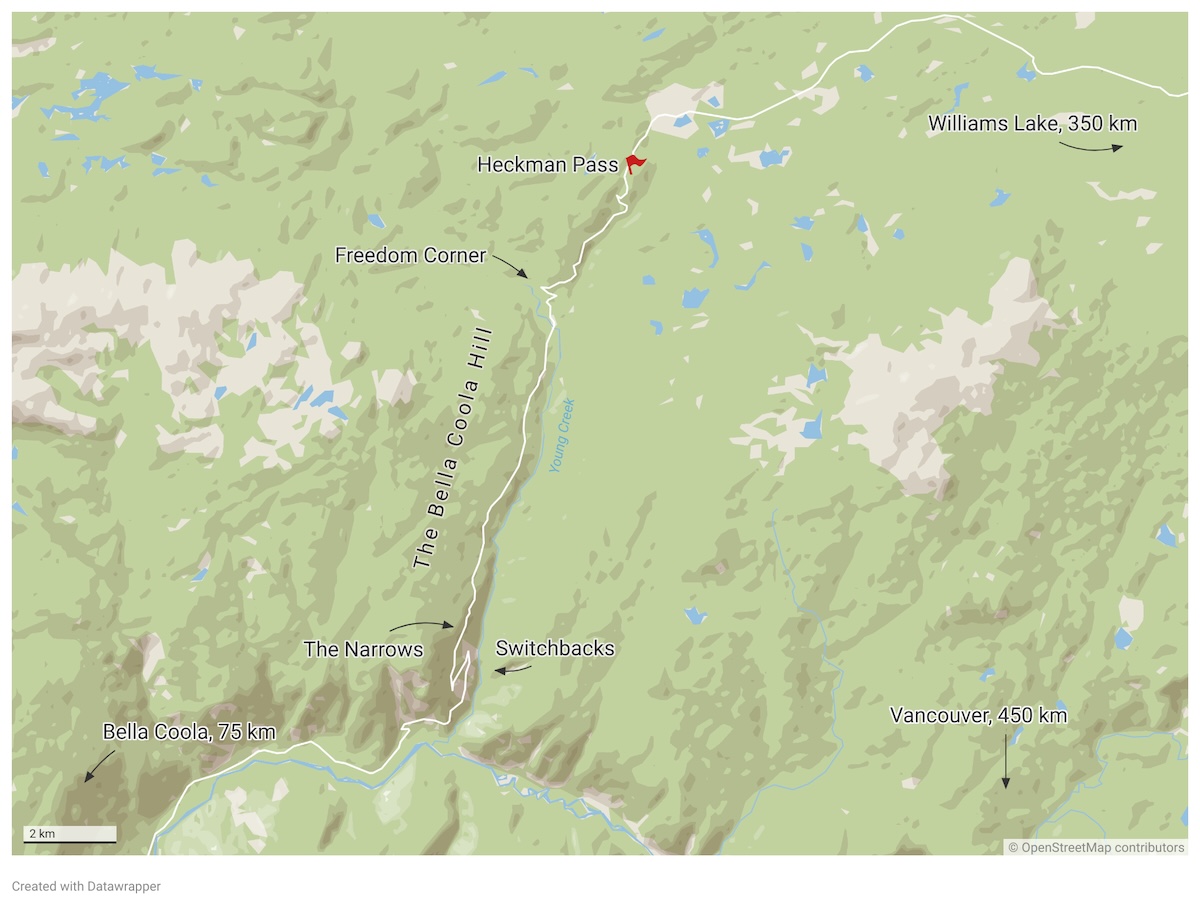
As the crow flies, Bella Coola sits about 450 kilometres northwest of Vancouver. The entire valley, a chain of communities extending 60 kilometres into the Coast Mountains, is home to about 2,000 people. Until mid-last century, it was accessed only by sea, air or pack trail — that is, hiking in with animals carrying goods and supplies.
Residents had waited decades on a government promise to build a road connecting them with the Interior. By the early 1950s, they were done waiting. If the government wasn’t going to build the road, they would build it themselves.
Work began with two bulldozers hired on credit. It would take just over a year, and cost about $70,000, to complete.
Among the road’s fiercest proponents was Cliff Kopas, president of the Bella Coola District Board of Trade and owner of the local general store. Nearly a century after Kopas Store was established in downtown Bella Coola, it remains a refuge for visitors seeking souvenirs and local knowledge.
Store manager Lorrein Gurr is also sometimes called upon to offer emotional support to road-weary travellers arriving in the community.
“A couple of weeks ago, a woman came in,” Gurr told The Tyee. “She says, ‘I am just shaking from that hill.’ She goes, ‘I was crying the whole way down.’”
The woman told her husband, “I’m taking the ferry out and you’re just going to have to pick me up in Port Hardy.”
It’s a frequent sentiment among visitors to the valley. But the mettle it takes to drive the road into Bella Coola is far outmatched by the determination it took to build it.
A road determined to be ‘impossible’
Talk of putting a road to B.C.’s central coast dates back to the 1800s.
The head of North Bentinck Arm, where the Bella Coola River flows into the Pacific Ocean, is home to the Nuxalk Nation. In 1894, a Norwegian colony settled in the valley. That year, the provincial government promised it would build a road to the Interior.
Fifty years later, that still hadn’t happened.
A road between the Chilcotin Plateau and Bella Coola was scouted in the 1920s, according to the Vancouver Province. Plans were “almost complete... following surveys by engineers who have been in the field all summer,” the paper reported on Sept. 23, 1929.
Construction was to “commence early next spring.”
Later, a report in the Vancouver News-Herald blamed the Depression’s effects on Bella Coola for the plan being shelved. But the economic downturn “touched lightly” on the isolated community, Cliff Kopas wrote in his 1970 book, Bella Coola: A Story of Effort and Achievement.
Instead, initial surveying had determined a road was “impossible,” he wrote. The government wouldn’t entertain the idea of building it.
“I was working on the packtrain when one of these big-shot engineers went through,” local resident Norm Saugstad told filmmaker Barb Grossman in her documentary The Hill. “We got talking and he says, ‘Well, you’ll never have a road through this country until the government is willing to put in about $3 million.’”
Years passed. Roads gradually extended west from Williams Lake and east up the valley from Bella Coola. By 1950, only 18 miles, or about 30 kilometres, of wilderness remained between their two end points.
Mapping out a route
The Bella Coola Valley is home to a network of First Nations grease trails that branch from Nuxalk territory into neighbouring territories. The trails were developed over millennia as a route for trading eulachon grease and other goods.
The main thoroughfare, the Nuxalk-Carrier Grease Trail, is the route First Nations guides brought Alexander Mackenzie down when he became the first European to travel east to west across Canada in 1793. Efforts are currently underway to revive it as a hiking trail.
But the road to Bella Coola doesn’t follow the grease trail. Instead, the route was identified in 1951 by locals exploring a pack trail known as the Bunch Grass Trail, which reaches the plateau by crossing the southern tip of Tweedsmuir Provincial Park — and ascending steep grades.
In addition to being shorter, the route had few creek crossings, reducing the impact to salmon and the need for costly bridges.
It was never formally surveyed. Instead, volunteers scouted the area “by plane, by horse and afoot” in the fall of 1951, according to the Vancouver Province. With hope for a road renewed, the Bella Coola District Board of Trade was formed, “its principal task to call attention to the need for a highway outlet to the Pacific Ocean.”
The following spring, the board’s president, Kopas, travelled to the BC Tourist and Highways Convention at the Hotel Vancouver to pitch the project. As other municipalities complained about the condition of their roads, he suggested “picking potholes out of all British Columbia roads and sending them to Bella Coola.”
“My community hasn’t got any of these problems,” Kopas told the convention in March 1952. “We haven’t any road. Would you please send us your potholes and we’ll lay them end to end and make a road of them.”
Late that summer, the Bella Coola board of trade sent a telegram to B.C.’s public works department in Victoria, announcing they were “going to start immediately” on a road.
Then they got to work.
On Sept. 14, 1952, Tatla Lake resident Alf Bracewell fired up a Caterpillar D6 and began building a road west from Anahim Lake. George Dalshaug would later begin pushing his four-cylinder International TD-14 up from the valley below.
“The throaty roar of a diesel tractor building a new B.C. road — every clank financed so far by private residents of this area — is echoing through the wilderness east of Bella Coola,” the Vancouver Province announced.
The board of trade had less than $250 in the bank.
As volunteers toil, BC promises ‘best roads in Canada’
A month earlier, in August 1952, B.C. had elected a new Social Credit government.
W.A.C. Bennett was embarking on what would become a 20-year run as premier, the longest in B.C. history. It was an era of rapid infrastructure expansion, particularly in northern and remote areas, with projects like the W.A.C. Bennett Dam and an ill-fated rail line to Dease Lake taking shape in the years that followed.
By the time the snow fell in November 1952, more than 50 kilometres of road had been constructed west from Anahim Lake to the top of Heckman Pass. The progress caught the attention of the newly appointed public works minister, Kamloops MLA Philip Gaglardi, and he granted them $10,000.
“What he didn’t tell them was that he actually had allocated $50,000,” Bella Coola resident John Morton says. “He only gave them $10,000 to keep them going and encourage them.”
At the same time, the government was preparing to spend big on B.C.’s highways.
By March 1953, during a $1-million push to invest more into northern highways, Gaglardi promised the board of trade an additional $20,000.
Ironically, the $30,000 the province had spent on the road so far was still $5,000 less than it had spent on the surveys that had found the job “prohibitively expensive,” the Vancouver Sun pointed out in an article.
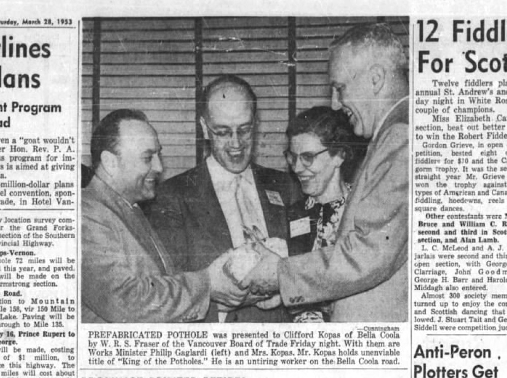
Later that month, Gaglardi boasted at the annual BC Tourist and Highways Convention about B.C.’s multimillion-dollar plan “aimed at giving the province the best roads in Canada.”
Kopas was presented with a pothole.
As work progressed on the highway, Thomas Squinas, a local rancher, trapper and guide from the Ulkatcho First Nation, was enlisted to refine the route, blazing a trail ahead of the bulldozers.
Newspaper articles from the time credit Squinas with having “built-in radar.”
“Thomas is legendary in that he showed them the way through,” says Bella Coola resident Harvey Thommasen, who got to know Squinas while working as a doctor in the community. “He was the one that basically helped them determine where the road should go, and then they just followed his flagged-out route.”
Squinas was intimately familiar with the area, says Sage Birchwater, a journalist and author of Ulkatcho: Stories of the Grease Trail. He had grown up in Anahim Lake and had a trapline that roughly followed the same route.
A February 1953 article in the Vancouver News-Herald describes a typical exchange between the guide and the foreman, a local forestry road builder named Elijah Gurr.
“[Gurr] would tell Thomas where he wanted to go. Thomas would say, ‘You want to go straight or the easiest way?’”
“Straight” was Gurr’s reply.
The crew was “carving a ledge into the side of a rock mountain,” Kopas writes.
By spring, they had less than 10 kilometres to go. But those final kilometres were the hardest, involving “miles of rock blasting [and] long rockslides,” according to the Vancouver Sun. Switchbacks were added in the steepest section near the bottom. Above, the road narrowed as the builders focused their efforts forward.
At times, the machines were “practically out on air,” Elijah Gurr’s son, Melvin, recalled decades later in The Hill. Melvin, at 16 years old, was the youngest ticketed powderman in B.C. and the youngest on the crew. He had been brought in to oversee the blasting.
Bracewell would recall, in the documentary Breaching the Barrier, working his Caterpillar along the most precipitous section of road, where the edge drops nearly a kilometre to the creek below, when the brakes suddenly failed. “I pretty near swallowed my chewing tobacco,” he said. Thankfully, he quickly regained control of the machine.
But Bracewell expressed no regret about the lack of safety protocols that came with building what would be dubbed the “Freedom Road.”
“The job was kind of nice, because we didn't have any government bureaucracy,” he said. “Nobody wore hard-toed boots and nobody had a hard hat.”
Unfortunately, the lack of government oversight also came with a lack of sufficient funds.
But the work continued.
“Machine owners, operators, cook, labourers all stayed with the job. Groceries were delivered, as was fuel oil and a thousand dollars’ worth of powder, all bought on credit and faith,” Kopas wrote in his book.
By the time the final, toughest stretch got underway, the government had provided the entire $50,000 earmarked for the project. The small community had collectively raised another $20,000.
They asked the province for $5,000 to finish the job. It declined.
“The men working on the project decided to carry on without any guarantee of getting wages,” the Vancouver Province reported.
When Gaglardi suggested in the legislature that the achievement was an example of free enterprise, local MLA Anthony Gargrave disagreed. It was a co-operative effort, he said.
“I know, because I have $50 in it,” quipped the New Democrat.
The province settles up, assumes responsibility
On Sept. 26, 1953, the two bulldozers touched blades.
“Dalshaug and Bracewell got off the iron seats which they polished white with their jeans during the past few months,” the Vancouver Sun reported. “They stood on the bruised front blades of the bulldozers and shook hands.”
The road had cost about $70,000 to build — less than $1 million in today’s dollars. That fall, the board of trade received a letter from the provincial government.
“Would you be so kind as to send us detailed bills re the last 2,800 feet of your road,” it said.
In December 1953, a cheque arrived that covered the board’s outstanding debts.
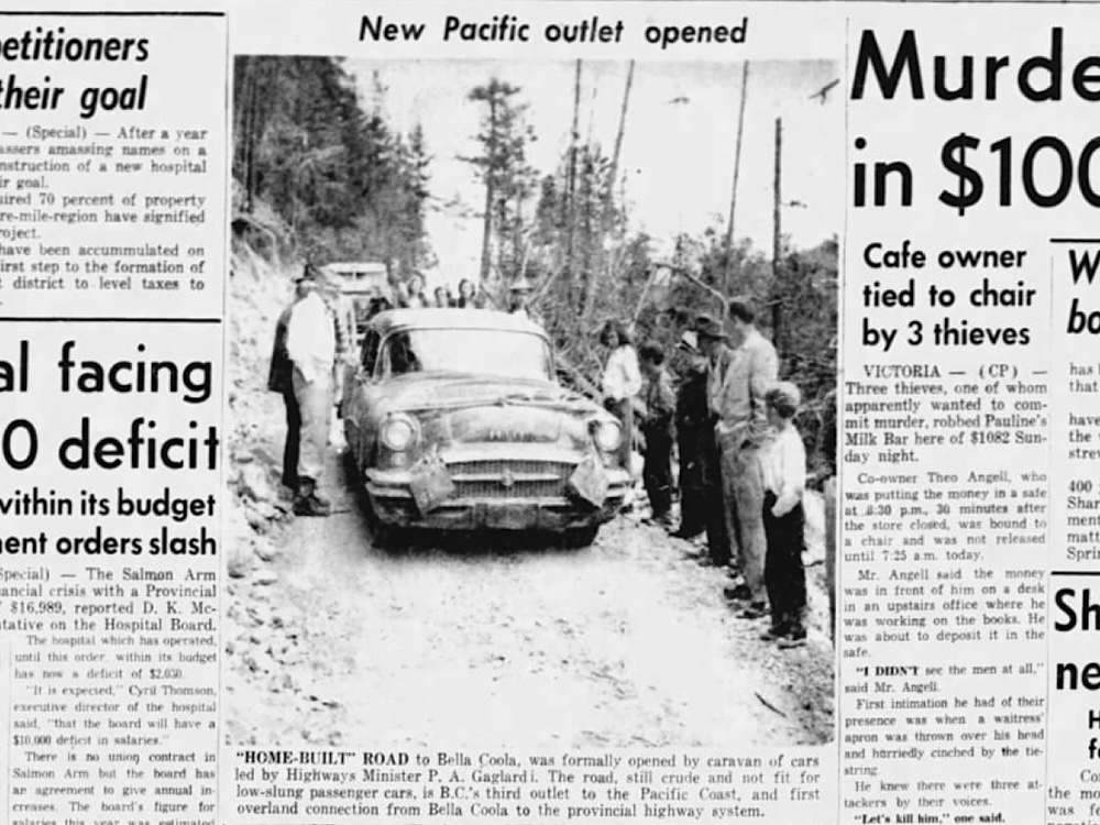
Two summers later, Gaglardi led a procession of vehicles that officially opened the road over the Hill.
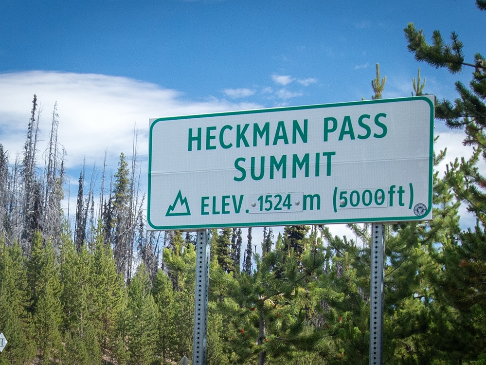
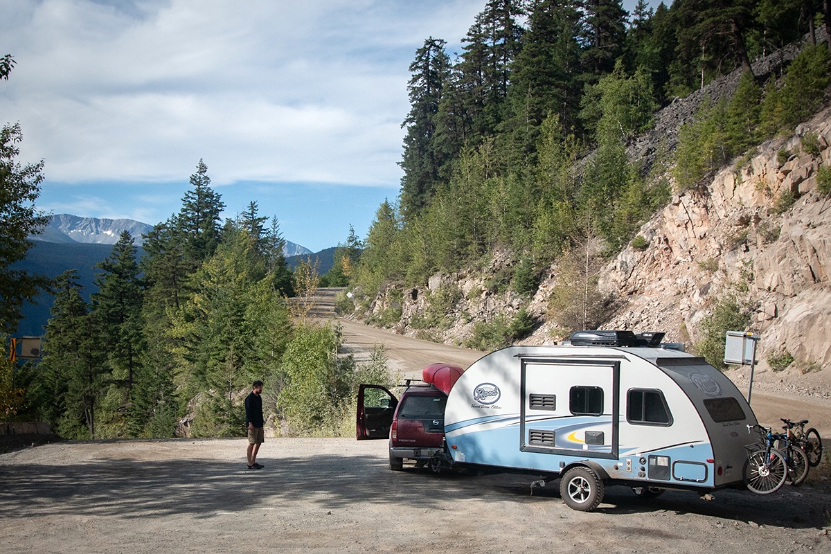
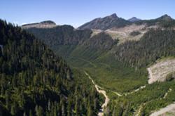
More than 70 years after Andy Svisdahl made his inaugural trip, the drive is still not for the faint of heart. From Heckman Pass, the road tips precariously toward the coast, dropping 1,200 metres in elevation over 18 kilometres and reaching 15 per cent grades — all capped off by the dizzying relief of the valley beyond.
“I don’t know of any other place in Canada, maybe even North America, that would go to that elevation in that distance,” says Stephen Waugh, the owner of Bella Coola Vehicle Rentals and former emergency program co-ordinator with the local regional district.
There have been “surprisingly few” accidents on the road despite the grades, Waugh adds.
Over the years, regular maintenance has gradually widened the road and softened its steepest inclines, pushing pullouts into its narrow shoulders. As it’s part of Highway 20, the Chilcotin-Bella Coola highway, contractors patrol daily to ensure it’s safe — and free of snow and rockfall.
“I’ve seen rocks the size of a car on the road,” Waugh says.
The road is still gravel and without guardrails. Paving it would turn it into “a luge run” in the winter, Waugh adds, and guardrails would impede snow removal.
B.C.’s Ministry of Transportation declined an interview to discuss road maintenance and provided few details about its work to keep the road safe, saying in an email that highway contractors are responsible for “grading and snowplowing, pothole patching, drainage and signage maintenance, bridge and gravel road upkeep and snow and ice control.”
“Given the grades, typical climatic conditions and seasonal use, this road is a priority for the local maintenance contractor,” a ministry spokesperson wrote.
Cliff Kopas’s pitch to the BC Tourist and Highways Convention has proven prescient nearly 75 years on.
Highway 20 traffic data collected west of Anahim Lake shows that road users mushroom during peak tourism season. From late July through September, when visitors come for fishing and bear viewing, more than 250 average daily road users were recorded last year, a 60 per cent increase over the remaining months of the year.
Anyone experiencing issues on the drive is unlikely to be stranded for long, Waugh says.
“I can’t think of anybody that wouldn’t help them,” he says. “That’s part of the charm of living in a place like this. Nobody will leave you on the side of the road.”
Locals travel with two-way radios, calling out their locations to alert other drivers. While the last of the road builders, Melvin Gurr, died last year, the team’s efforts live on in the landmarks established during the building of the road: lower switch, upper switch, freedom corner and the narrows are just a few.
Most are accustomed to the heights. They know to gear down and reduce pressure on the brakes, give lots of space around blind corners and keep speeds in check.
“I’m not fazed by it anymore,” says Lorrein Gurr.
In the case of the woman who insisted on taking the ferry out, Gurr thinks, with a little encouragement, she was persuaded to drive the road. But stories abound of visitors abandoning rental cars in favour of flying home or begging locals to tow their RVs up the Hill.
“Some people are terrified of it. Then other people are like, ‘Oh, that was nothing,’” Gurr says.
“It’s not nothing,” she adds. ![[Tyee]](/design-article.thetyee.ca/ui/img/yellowblob.png)
Read more: Transportation








Tyee Commenting Guidelines
Please note that email notifications for replies are not currently working due to a software issue which may be resolved in a future update.
Comments that violate guidelines risk being deleted, and violations may result in a temporary or permanent user ban. Maintain the spirit of good conversation to stay in the discussion and be patient with moderators. Comments are reviewed regularly but not in real time.
Do:
Do not: