


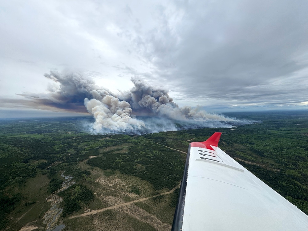
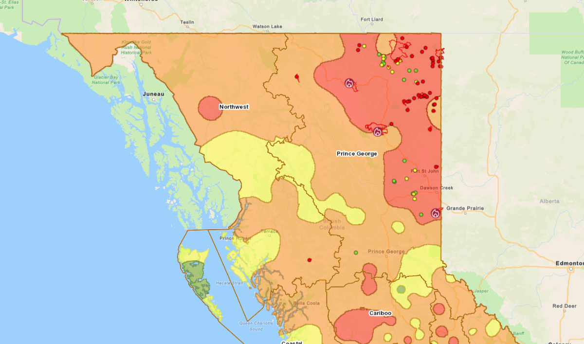
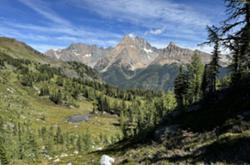
As wildfires rage in B.C.’s northeast, experts are warning that several other parts of the province are emerging as high-risk areas as a result of lower-than-average snowpack, warm weather and ongoing drought.
“The likelihood of an active fire season is growing in regions of the province with persistent drought, including the southwestern Interior, the Chilcotin and the far northwest regions,” Neal McLoughlin, superintendent for BC Wildfire Service’s Predictive Services Unit, said in a news conference Monday.
McLoughlin added that the province’s northeast remains “the region of greatest concern.” Some communities are already being pushed to evacuate.
The northeast “will experience continued fire activity through the summer, given their multi-year drought conditions and presence of overwintering fires that have shown up this spring,” McLoughlin said.
Over the last two wildfire seasons, the Prince George Fire Centre, which encompasses northeast B.C., has accumulated around 18 per cent burned area. This season could push that number to 30 per cent, McLoughlin told The Tyee in an interview.
“This is a fire season that didn’t stop for three years straight,” said McLoughlin. “We’re starting to ask the question ‘When does the fire season end in the northeast of B.C.?’”
Experts flagged several other additional areas as cause for concern.
The province monitors things like historical weather patterns, current conditions, forecasts and fire activity across the province to determine potential risk, BC Wildfire Service said in an email to The Tyee. When wildfire risk is high, it sends crews and other resources to those areas in advance.
Other variables are harder to predict, like wind and lightning. According to a B.C. wildfires report, in the 2023 wildfire season, 71 per cent of wildfires were sparked by lightning strikes.
Although lightning strikes haven’t factored in much yet this year, the season doesn’t peak until July or August, McLoughlin said. Human-caused fires have accounted for 70 per cent of all wildfires reported in 2025, a statistic expected to “flip-flop” as lightning becomes the predominant factor later in the season.
Despite the unpredictability of wildfires, there are ways that experts can track and predict which regions could be problematic throughout the province.
The overwhelming factor at play in B.C. this season is drought, said Kelly Greene, minister of emergency management and climate readiness.
“The frequency and severity of drought is increasing due to climate change,” Greene said at Monday’s briefing, adding that dry conditions put pressure on things like food security, industry, ecosystems and community well-being.
“Responding to and preparing for drought is a priority,” Greene said. “Depending on how the summer unfolds, we may need to be more mindful of our water usage by building water efficiency into our daily routines.”
B.C. Forests Minister Ravi Parmar said more than 80 active wildfires are currently burning in the province and early modelling shows that “much of the province is trending towards warm and dry conditions.”
“The province is hoping for the best but preparing for the worst,” he said.
Low snowpack in the Chilcotin
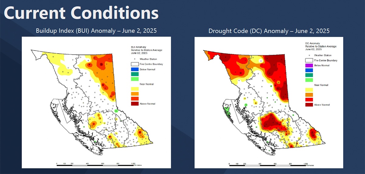
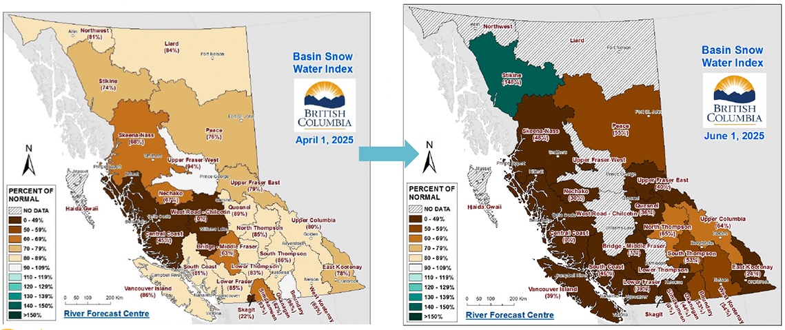
David Campbell, head of B.C.’s River Forecast Centre, said at Monday’s briefing that early spring snowpack conditions showed below-normal snowpack across the province, “particularly in areas around west-central B.C. and the Chilcotin.”
The low levels are coupled with rapid snowmelt over the past week due to warm temperatures, he added.
The low snowpack combined with early snowmelt means there’s less water in the system heading into the summer.
“About two-thirds of the snow that we started with this year has now melted,” Campbell said. “In a normal year, we would only have melted about half of that.”
Maps shared during the briefing show that the region west of Williams Lake, which surrounds the Bella Coola valley on B.C.’s central coast, was below 49 per cent of normal snowpack on April 1. Since then, areas showing lower-than-average snowpack have expanded to cover much of the province’s southern two-thirds.
That is increasing the risk of wildfires closer to the coast.
On Tuesday, the District of Squamish, which lies within this area, declared a state of local emergency due to a wildfire posing an “existing or imminent threat to people and property,” according to an order signed by Mayor Armand Hurford.
Whether the region gets rain, along with what its temperatures are like this summer, will be the “key driver” for how the wildfire season unfolds, Campbell said.
A pocket of concern in northwest BC
The upper western corner of the Northwest Fire Centre, about 70 kilometres west of Iskut, has also been highlighted as a higher risk because of drought conditions.
The concern is fuelled by above-normal drought conditions and areas of above-average temperature throughout the month of June in the upper west corner of the northwest region.
However, maps shared in the Monday briefing show that the southern half of the region is experiencing near-normal drought conditions. That’s not out of the ordinary, McLoughlin explained. “You can have really high fire danger conditions in one region of the province, and it can be wet and low fire danger in another,” he said.
Late fires in southeast BC
In B.C.’s southeast, where fire danger maps show a large area of extreme risk surrounding Invermere and smaller pockets throughout the region, a prolonged fire season last year is partially to blame for heightened risk heading into this season.
Residents in the Southeast Fire Centre faced evacuation orders and air-quality warnings as a result of wildfires all the way into September.
It's “not typical to get fires that late in the season,” McLoughlin said.
Following patterns seen elsewhere in B.C., McLoughlin said drought was to blame for the extended season, adding it contributes to higher risk heading into the following season.
“Three of the factors that we look for when we think about a prolonged fire season are drought, and specifically drought that’s carrying over from previous years, low snowpack like we’ve seen recently and absence of spring rain,” McLoughlin said.
These conditions in the southeast region are projected to persist. In the Monday briefing, the province said the southeast corner of the province has experienced slightly above-average temperatures this spring combined with abnormally dry conditions.
Evacuation orders in the northeast
There are currently 10 evacuation orders affecting 120 households in the Prince George Fire Centre, as well as five evacuation alerts, Emergency Management Minister Kelly Greene said on Monday.
McLoughlin said the amount of rain required to mitigate the persistent drought in northeast B.C. is “unlikely this summer.”
“We would need upwards of 150 millimetres of rain over the next three weeks to really make a dent in some of those high drought levels,” he said. “We’re just not seeing that in the outlook.”
As McLoughlin explained, “drought and dry weather patterns are fuelling these overwintering fires.”
Overwintering fires are incredibly hard to extinguish because they are buried deep underground, he said.
McLoughlin added that previously burned areas are acting as a natural fire break and working against fire spread in the northeast by containing active wildfires.
“But there still is a lot of forest outside of those disturbance areas for the last two seasons that could still burn this year,” he added.
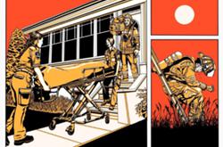
Preparing for fires in high-risk areas
Currently, one of the most effective ways in which communities are protecting themselves from forest fires is through cultural and prescribed burns, McLoughlin said.
On the individual level, Greene encouraged B.C. residents to be prepared for potential wildfires in their region by having a grab-and-go bag ready, keeping homeowner’s and renter’s insurance up to date, and downloading the BC Services Card app.
The province is also encouraging individuals and communities to participate in the FireSmart BC program, which provides resources on how to make homes and communities more resilient to wildfires.
“Some of the best bang for your buck for stopping your home from burning down starts within five feet of your home,” said Kevin Kriese, land use and wildfire policy analyst with the Polis Wildfire Resilience Project at the University of Victoria.
McLoughlin said the government also needs to start taking an all-hands-on-deck approach, expanding the issue of wildfire management into conversations with other ministries, such as Water, Lands and Resource Stewardship.
“We’re out of time with respect to climate change,” said McLoughlin. “Fire regimes are escalating faster than we can manage on the ground.” ![]()
Read more: Environment


Tyee Commenting Guidelines
Please note that email notifications for replies are not currently working due to a software issue which may be resolved in a future update.
Comments that violate guidelines risk being deleted, and violations may result in a temporary or permanent user ban. Maintain the spirit of good conversation to stay in the discussion and be patient with moderators. Comments are reviewed regularly but not in real time.
Do:
Do not: